Showing posts with label cliff dwellings. Show all posts

Wednesday, September 12, 2012

Canyon de Chelly Arizona

 
ROAD TRIPPING FROM BLUFF UTAH
TO
CANYON de CHELLY ARIZONA
(we hold copyrite to ALL photographs!) 
After spending 3 days exploring around Bluff Utah, Chuck and I headed to Chinle AZ and
Canyon de Chelly National Monument! (Pronounced Canyon de Shay)
We left Bluff almost a month ago! WoW!  Where did all that time go?  We followed Highway 191 from Bluff to Chinle and why this isn't marked as a scenic highway, I will never know!  Beautiful rock monuments and red stone cliffs, beautiful valleys and a wonderful road with NO TRAFFIC! I mean if we met 20 vehicles between Bluff and Chinle, I would be surprised!  Now for the spoiler....   be sure your gas tank is full before exploring this highway. You will be driving the backroads of the Navajo/Dineh reservation!  Going through settlements named Mexican Water, Rock Point, Round Rock and Many Farms before arriving at Chinle! It was a leisurely 3 or so hour drive from Bluff to Cottonwood Campground at Canyon de Chelly .


ENJOYING THE COTTONWOOD CAMPGROUND
 
Cottonwood Campground is a well maintained campground full of the cottonwood trees for which it was named providing nice shady sites. NO HOOK-UPS
You will be dry camping here. The sites are all paved and level with some pull through's but mostly back in. It's only $10 per night.


The campground was almost empty! We got there on a Friday night... August 17th!  The little Casita belongs to the workamper. There are handicapped sites available right next to the restrooms.

NAVAJO ARTISTS ALONG THE WAY...

There were Navajo artists at several of the overlooks with quality work, not the usual cedar beads you find.


This man had beautiful pottery, he was carving very intricate designs into this pot with an exacto knife! He had several pieces I really liked! We stopped by on our way back to buy one but he was gone!


 This lady has created a beautiful necklace using coral and silver!  I was really tempted because it was so nice! Not the traditional work you usually see but very interesting.
 

THE CANYON....
 
Archaeological evidence shows that people have lived in the canyons of Canyon de Chelly for nearly 5,000 years, longer than anyone has lived uninterrupted anywhere on the Colorado Plateau.
 
 I love this photograph that Chuck took...  looks like canyon spirits in the shadows headed down the stairs!  Several look like Kokopelli !  Chuck will be taking the rest of the photos...  I just can't do the cliff edge heights anymore! The 26 miles of canyon cliff walls, some rising up to 1,000 feet from the canyon floor! 
 
I couldn't believe this couple, casually perched on the edge of the canyon with nothing but air between them and the canyon floor far below!
 
 
The rains flow into the canyon floor providing farming for the families who live in these canyon walls.


Everything looked pretty dry when we were there in August!

 There are huge monuments on the canyon floor

 People we call Basketmakers built homes,storage facilities and social/ceremonial complexes high on ledges in the walls of the canyon cliffs. The alcoves in the cliff wall above and cropped in closer below were used for storage. Usually food would be stored here.

 In the close up and cropped photo, you can see the rock structures built within each alcove.  But look how high it is from the canyon floor and how treacherous it would be to descend to the grainery from above!
 
The camera lens we were using wasn't able to capture these cliff dwellings circled above! How did they ever get to them???
About 700 years ago the Anasazi (ancient ones) culture, who built these homes within the canyon walls, disappeared. Later, migrating Hopi Indians and other tribes spent summers hunting and farming here. You can enlarge the image somewhat by clicking on it.

 This is known as "Slide Ruins"

The more famous of the cliff dwellings is the White House Ruins. A fairly easy 1.5 mile hike down to the ruins gets you up close and personal with them.

The most recognisable feature of Canyon de Chelly is Spider Rock. Here, you can see the river far below that makes farming here possible.

A wide angle view of Spider Rock shows the awe inspiring beauty that is Canyon de Chelly!
 
There is a second campground near Spider Rock. This is a campground I would never recommend to anyone except bravehearted tent campers!  Certainly no RV's of any size, style or type could ever find a spot level enough or big enough to accomodate you. Extremely twisty interior dirt roads made navigating my Chevy TrailBlazer a challenge! Even trying to find our way out of this campground maze was a challenge!  Avoid this one for sure, the campground at the entrance known as Cottonwood is wonderful!
 
We loved our 2 days here, wish we could have stayed longer.  But we were rushing to get here Mimbres NM to our new workamping job.  This area of New Mexico is beautiful! Cool weather too! The cottonwood trees down by the river are turning golden we are looking forward to Autumn!
 
Happy Trails until we meet again!  Geri, Chuck and the HoundHerd Scotty, DoogieBowser and Radar!


 Loved the back window of an RV we saw in South Dakota!


Wednesday, July 6, 2011

County Road 146

This is how Chuck and I spent July 4th, 2011!


First you have to go north on Highway 191,  16 miles to County Road 262 towards Hovenweep National Monument. When the road start getting real bad, look for Hatch Trading Post on the left.  It is all covered in trumpet vines and not hard to miss. It is all fenced in and vines are everywhere, the first piece of obviously cultured green life in the desert! Reset your odometer to zero and let the journey begin. (I can't believe I didn't take a photo of Hatch Trading Post!) Just past the trading post is the road to Hovenweep, do NOT take that right hand turn, go straight! Sooner or later you will find a sign that tells you that you really are on County Road 146!
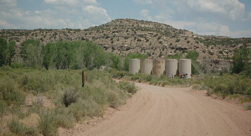
Remember to reset your odometer at the trading post to zero. At 9.3 miles you will see an oil terminal, turn right, this is County Road 146.  The county road signs out here are very small and difficult to read!


This rock looks like a mushroom that has lost it's top!

The nearby rock is just a weird rock column with flat black rocks on top!

The road is pretty much 2-lane road! Good thing we never met anyone the whole trip!

 At 9.8 miles, you will find the first Petroglyph panel.
It will be on your left!
Click on each image, you can make the photo full size.

There have been many years of rock art here, some images are drawn over other older images!


We passed an old abandoned cabin. Must have been a small working ranch at one time.


The road meanders through some interesting country

This is also oil country, you will pass several grasshopper oil rigs and collection areas like this!

 At 12.9 miles you will see another panel off to the left.

Like the other panel, this will have some newer art drawn over the old. Click on each image to see it full size.


In these two photos, you will see an example of modern rock art.  A Navajo (Dineh) family with a horse drawn wagon.

It looks as though this had once provided shelter, some rocks were stacked pueblo style.

Most of the sites are easy to find, there will be a short side road leading off main road, beware of soft sand!

Just past the last petroglyph panel, you wil drive through a great cottonwood grove. The temps dropped 10 degrees in here under the trees. Good place to walk the dogs! Great place to boondock if you have a smaller RV or camper... road is tricky in a few places!

The road becomes even more narrow

The road becomes more challenging with high twisty curves, but it is a do-able road, 4 wheel drive would 
be good!

At 16. 7 miles, you will arrive at 3 Kiva Pueblo Ruins!
Very interesting! 


You can climb down the ladder into the Kiva, but we chose not to.  Too hot at 102 degrees to consider doing this!


At 18.6 miles, look up high on your left! You will see the remains of some pueblo cliff dwellings!


Back on the road again,

 The road continues to curve in "S" curves, sometime over high cliffs leaving the passenger, 
(me!) breathless! But remember.... I am a relunctant passenger! I would rather drive!

 We passed an old abandoned cabin that Chuck thought might possibly be a line shack, where the cowboys go in winter to keep an eye on the cattle.


If you look across this field, click on to enlarge, you will find 3 caves cut into the wall of sandstone!


We were surprised to see that a local rancher uses 
them for storage! The first stored farm implements,
this middle one held hay, the third one held tractors and equipment!


The road gave us two more surprises before we were done.... but my camera was done, dead battery! Just around this sandstone formation, we found a beautiful home built into the sandstone. Not like the cliff dwelling of old, all you could see were beautiful windows and a front door and several solar panels! It was amazing and I am sorry (DUH!) that I didn't bring spare batteries! Life goes on. You will just have to plan a trip here and go exploring with your own camera and spare batteries! The dirt road emerges back on Highway 191, 42.8 miles from Hatch Trading Post and about 25 miles from the campground! We had a great 4th of July! Thank you for joining us!  Our next blog will be from Sand Island where we found another great petrogyph panel, and Newspaper Rock a well known petrogyph pane and Canyonlands National Park, the southern end of the park we visited while in Moab.
Tomorrow the adventure begins again, we leave Bluff and head out to Monument Valley! On the road again!


Happy Trails, reporting to you from The MotherShip docked in Bluff Utah!
Geri, Chuck and the hound herd, Scottie, Doogie Bowser and Radar!